


FAA INFORMATION EFFECTIVE 06 FEBRUARY 2014
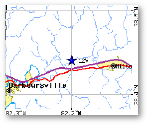
FAA Identifier: 12V
Lat/Long: 38-26-27.2000N / 082-12-02.8000W
38-26.453333N / 082-12.046667W
38.4408889 / -82.2007778
(estimated)
Elevation: 572 ft. / 174.3 m (surveyed)
Variation: 06W (2000)
From city: 4 miles W of MILTON, WV
Time zone: UTC -5 (UTC -4 during Daylight Saving Time)
Zip code: 25545
Airport Operations
Airport use: Open to the public
Activation date: 09/1987
Sectional chart: CINCINNATI
Control tower: no
ARTCC: INDIANAPOLIS CENTER
FSS: ELKINS FLIGHT SERVICE STATION [703-724-4288]
NOTAMs facility: EKN (NOTAM-D service available)
Attendance: 0800-DUSK
Wind indicator: yes
Segmented circle: no
Lights: SS-SR
Airport Communications
CTAF/UNICOM: 122.8
HUNTINGTON APPROACH: 124.1 119.75
HUNTINGTON DEPARTURE: 119.75 119.75
WX ASOS at HTS (17 nm W): PHONE 304-453-3408
APPROACH / DEPARTURE CONTROL SERVICE PROVIDED BY HUNTINGTON APPROACH CONTROL (HTS) ON FREQ 119.75/270.10.
Nearby radio navigation aids
VOR radial/distance VOR name Freq Var
HNNr207/20.5HENDERSON VORTAC115.9003W
HVQr288/21.0CHARLESTON VORTAC117.4003W
ECBr065/37.5NEWCOMBE VORTAC110.4002W
YRKr113/38.5YORK VORTAC112.8005W
Airport Services
Fuel available: 100LL
24 HR SELF-SERVE.
Parking: hangars and tiedowns
Airframe service: MINOR
Powerplant service: MINOR
Runway Information
Runway 7/25
Dimensions: 3154 x 40 ft. / 961 x 12 m
Surface: asphalt, in good condition
EXTENSIVE CRACKING
Runway edge lights: low intensity
RY 07/25, NSTD LIRL LIGHTS, NSTD SPACING AND COLORS.
Runway edge markings: MARKINGS FADED.
RUNWAY 7 RUNWAY 25
Latitude: 38-26.320483N38-26.586017N
Longitude: 082-12.330133W082-11.762300W
Elevation: 567.1 ft.569.4 ft.
Traffic pattern: leftleft
Runway heading: 065 magnetic, 059 true245 magnetic, 239 true
Displaced threshold: 134 ft.
07/25 DSPLCD THLDS NGTS ONLY; DSPLCD THLD UNMARKED.129 ft.
07/25 DSPLCD THLDS NGTS ONLY; DSPLCD THLD UNMARKED.
Markings: basic, in fair condition basic, in fair condition
Touchdown point: yes, no lightsyes, no lights
Obstructions: 100 ft. trees, 700 ft. from runway, 250 ft. left of centerline, 5:1 slope to clear20 ft. gnd, 201 ft. from runway, 170 ft. right of centerline
RY 25, 20 FT HILL, 200 FT FM RWY END, 172 FT RIGHT, 40 FT TREES, 201 FM RWY END (DSTC), 75 FT L.
Airport Ownership and Management from official FAA records
Ownership: Privately-owned
Owner: ONA LAND MANAGEMENT SERVICES, LLC
PO BOX 88
ONA, FL 25545
Phone 304-710-5650
Manager: BILL & LYNN BAUER
PO BOX 88
FT. LAUDERDALE, FL 33309
Phone 304-710-5650
Airport Operational Statistics
Aircraft based on the field: 42
Single engine airplanes: 40
Multi engine airplanes: 2
Aircraft operations: avg 90/week *
85% local general aviation
15% transient general aviation
* for 12-month period ending 01 July 2012
Additional Remarks
- VEHICLES CROSSING RY.
- BALLOON PORT 2 MI E.
- NOISE ABATEMENT PROCEDURES IN EFFECT; DEP RY 25 SHOULD HEAD 240 DEGS & DEP RY 07 SHOULD HEAD 090 DEGS TO 1600 FT ALTITUDE.
- RY EXIT TO RAMP HAS DEPRESSION MARKED BY CONE.
- FENCE, POLES, BLDGS, IN PRIMARY SFC, WEST SIDE.
- RACE TRACK ADJACENT TO RY 07/25.
- RY 7/25, DSPLCD THLDS UNMARKED. THLDS MARKED AT RY ENDS.
A52-09 +300 HILL 5000' ON EXTDD CNTRLN.
Instrument Procedures
NOTE: All procedures below are presented as PDF files. If you need a reader for these files, you should download the free Adobe Reader.
NOT FOR NAVIGATION. Please procure official charts for flight.
FAA instrument procedures published for use between 6 February 2014 at 0901Z and 6 March 2014 at 0900Z.
IAPs - Instrument Approach Procedures
GPS RWY 07 **CHANGED** download (131KB)
VOR-A **CHANGED** download (154KB)
NOTE: Special Take-Off Minimums/Departure Procedures apply download (149KB)
Other nearby airports with instrument procedures:
KHTS - Tri-State Airport/Milton J. Ferguson Field (17 nm W)
KGAS - Gallia-Meigs Regional Airport (24 nm N)
KDWU - Ashland Regional Airport (26 nm W)
3I2 - Mason County Airport (29 nm N)
KCRW - Yeager Airport (29 nm E)